Oct 23, 2006

Rattlesnake Mountain Trail

Rattlesnake Mountain is part of the Issaquah Alps of the Western Cascades. It sits between SR-18 on the west and Rattlesnake Lake on the east, spanning about 7 miles. It reaches a peak of 3250 feet.

In recent years, the trail system on Rattlesnake Mountain has been revamped. There is now a groomed trail, without logging roads, that runs from Snoqualmie Point on the west side of the mountain all the way to Rattlesnake Lake. The trail is 11 miles long, with an elevation gain of about 2200 feet from either end.

My wife and I undertook this hike yesterday, our most aggressive to date. For the first time on our hikes we left the kids behind, as this is too aggressive for young kids (we did see a teenager running up Rattlesnake Ledge TWICE... wow, to be young and in shape again).

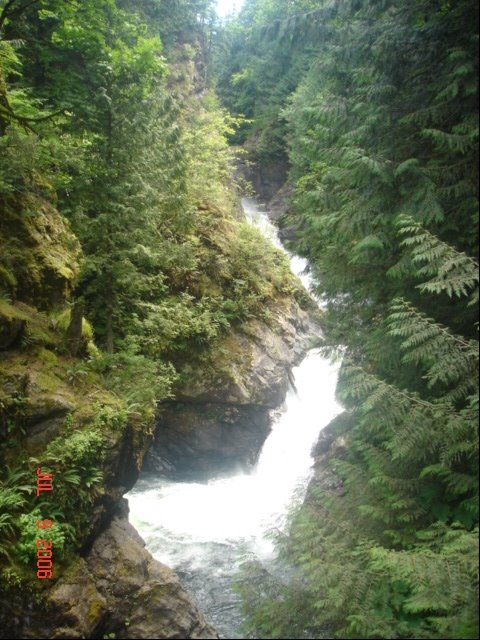
The trail wanders through different terrain; first on grass and trees, then through thick forest, then opens up to an area that's been logged, then through thick, shoulder-high brush, back through an open area, then through tall evergreens, then through brush again, then through a nice dirt path, and finally through rocks. It is quite varied and the change of scenery every mile or so is refreshing.

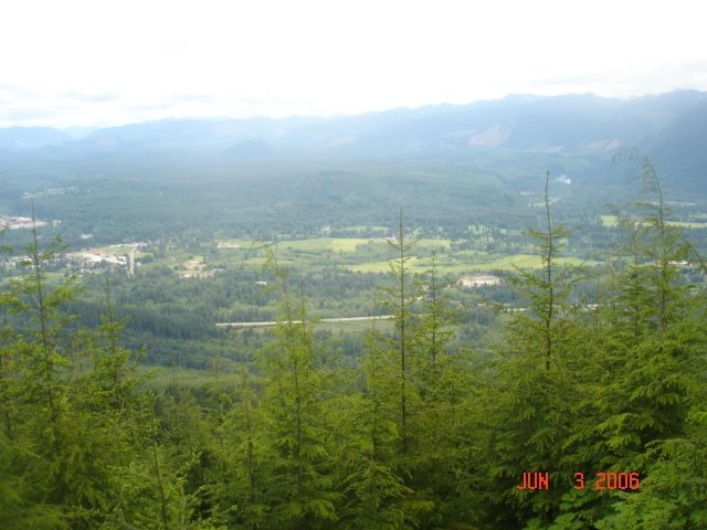
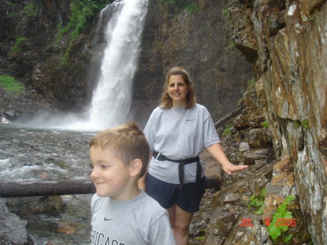
We started this trip from Snoqualmie Point (which in and of itself is fun, with a great view of Snoqualmie Valley, hence the name). At about two miles you get to the first great viewpoint. Another three miles will get you to "Grand Prospect", which lies directly north of North Bend (it's the peak you see as you drive north to the I-90 interchange). The next two miles will take you up and down between Grand Prospect and East Peak. The East Peak has some great views as well, peeking behind Mount Teneriffe. The East Peak is the highest point on this trail, at 3250 feet. From there, it's downhill. A mile and a half from the peak you will get to the first of three "Rattlesnake Ledges." The other two are a quarter mile away each. The last two miles is a long walk down from Rattlesnake Ledge to Rattlesnake Lake. This last stretch is the most popular stretch - most people hike/run this stretch only. On this day (a beautiful Sunday) we only met two people that were hiking the entire trail.

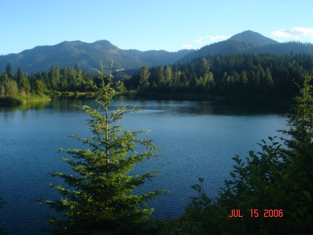
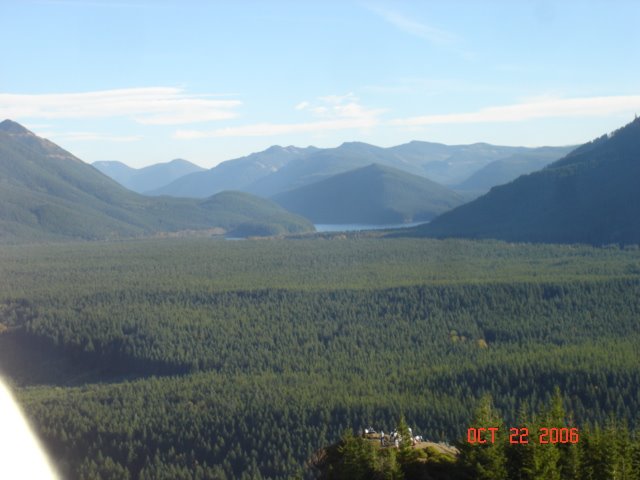
The views are simply magnificent. We chose a perfect day, and could see deep into the Cascades in every direction.


Whew... just 11 miles to go!


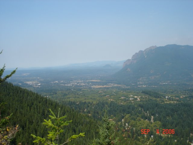
The twin peaks view... Mount Si (left), Mount Teneriffe, and North Bend from Grand Prospect.


Snoqualmie Valley due north... you can can barely see Mount Teneriffe on the left... from a side trail off east peak (some say this is the best view from Rattlesnake Mountain).


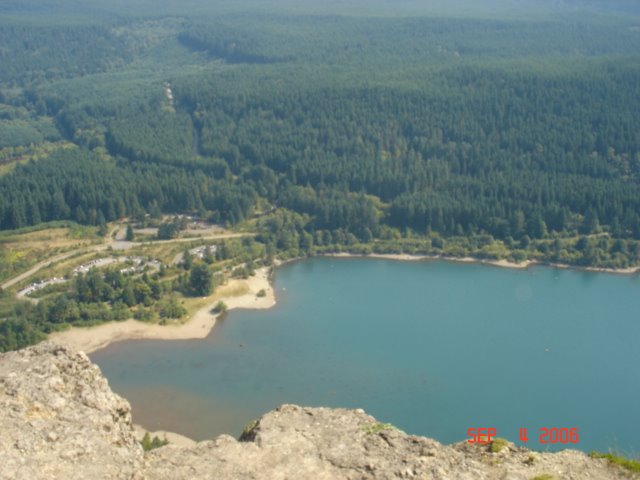
The lowest RattleSnake Ledge as seen from the "second ledge." (Look for the people at the bottom of the picture)

Oct 20, 2006

The Preston-Snoqualmie Trail

No pictures of this, but I biked along the Preston-Snoqualmie Trail from the trailhead in Preston down to the "other side" of Snoqualmie Falls. About a 5 mile long trail is all, but very nice, and it's paved between Lake Alice and Snoqualmie Falls. Perfect for biking or even a walk.

I enjoyed the view of Snoqualmie Falls from the end of the trail. Nice view, and benches to relax and enjoy.

The trail runs right under Snoqualmie Ridge (it's maybe a quarter mile from my house, but would take a good couple mile hike to get to it) to the north, and opens to the Snoqualmie Valley to the south. This time of year was beautiful with the leaves turning color. Even with the rain, the views were impressive.

I've actually walked this before with the family, and both times I've been on it it's been fairly busy. A popular trail for dogs.

If you're going to walk, I suggest parking at the Lake Alice Road trailhead near Fall City and head east to the Falls.

Sep 30, 2006

Another Snoqualmie Valley Trail hike

This was a short hike with my two sons (ages 1.5 and 5) simply enjoying the trail between the Snoqualmie trailhead and the Tokul Creek bridge. On a fall day, with the leaves turning color but still on trees, this was simply an awesome walk. We wandered on some nicely groomed side trails today, and didn't realize there were as many side trails that lead to side trails that lead to side trails. Many a choice, and even though the trailhead to the bridge only measures a half a mile, we spent three hours exploring the side trails. The boys had a lot of fun, and every junction turned into a five minute debate on where to go.

As for Tokul Creek, we took the time to enjoy the views today (last time I was on my bike and didn't really take time to appreciate where we were). We walked to the center, dead above the creek below, and checked out the view from both sides of the bridge. Unbelievable. The creek runs through a gorgeous assortment of rocks and trees about 150 feet below the bridge, and the way the bridge is constructed you literally can look straight down (they have a gap between the walkway and fence). Definitely not for those afraid of heights, but I'm not sure I've seen a better view in the valley. Time of year had an impact for sure.

I highly recommend this trail between Snoqualmie and Fall City. Just amazing how it winds through the hills. Oh yeah, a warning... the Snoqualmie Valley Gun Club is below the trail in the valley, so hearing LOUD gunfire is normal :)

Sep 17, 2006

Favorite Summer Hikes in Snoqualmie

Ok, now that fall is here (at least weather-wise), time to recap the best family summer hikes in the Snoqualmie area.

Number 5: RattleSnake Ledge

Take a 1200+ elevation gain, two mile hike up to Rattlesnake Ledge for amazing views of the Snoqualmie Valley. Then enjoy a refreshing dip in Rattlesnake Lake. Great combination, and the large lake leaves plenty of space for

Number 4: Franklin Falls

This is a nice 1.1 mile hike from the trailhead, bringing you to the base of Franklin Falls where you can enjoy the mist from the falls or even pass under the falls.

Number 3: Snoqualmie Falls

Here you hike down to the base of the falls, an elevation change of 650 ft or so.

Number 2: Twin Falls

I like this hike because it starts off right along the Snoqualmie River, to the point where kids, and adults, can play in the river and refill water bottles. It then proceeds through a well groomed trail to the Twin Falls area with great views.

Number 1: Denny Creek Slippery Slab

This is a no-brainer - easily the best place in the summer for a hike. Our kids now ask for it by name!

Sep 16, 2006

Jak's Restaurant in Issaquah

What is a post about a restaurant doing in a hiking blog? Good question. With the popularity of this blog I've decided to expand into reviews of other things in the Snoqualmie Valley.

For example, for the last year or so Amy and I have been on a quest for a good steak place, something that is commonplace in Chicago (to the extent that we never did hit all the good steak joints). Ruth's Chris was the best we could find, and frankly as a "great" steak place Ruth's Chris doesn't impress me. Good stuff, but overpriced.

One of our friends recommended Jak's in Issaquah, but warned us of the notorious long waits. A couple months ago on our anniversary (it fell on a Thursday), Amy and I decided to give it a try. Wow, were we so not disappointed.

Funny, it took us three trips around the bring to actually find the place. It is as close to as a hole in the wall as you can get. I'd be surprised if there were 15 tables there (a few of them 2 seaters), and you can maybe fit 8 people at the bar. No wonder there are long waits.

But the steak was amazing. As good as the Chicago chop houses for sure. And the sides, which is how Chicago chop houses differentiate themselves, were outstanding as well. The potato pancakes are their specialty.

Service was outstanding as well. When we were told it would be a half hour wait, Amy and I headed down the block to a watering hole. 10 minutes later, the waitress was asking us if we were the Reagan party - Jak's had called and told us our table was ready. Pretty obvious that watering hole does a lot of business with Jak's waiting list.

Can't wait to get back. I've tried the Metropolitan Grill in downtown Seattle, and Jak's beats it hands down.

Sep 4, 2006

Rattlesnake Ledge

Rattlesnake Ledge overlooks Rattlesnake Lake, North Bend, and the middle fork of the Snoqualmie River. It is essentially the west end of Rattlesnake Mountain.

You can hike to the ledge from Rattlesnake Lake (Exit 32 off I-90). The trail is about 1.5 miles long, with an elevation gain of about 1200 feet. The trail is well groomed, and is kid-friendly. On this Labor Day afternoon it was quite busy as well!

Rattlesnake Ledge itself is quite expansive, with plenty of room to accomodate numerous hikers. It provides a great view of North Bend and Rattlesnake Lake, as well as a great eastward view of the Snoqualmie Valley and Cascade Mountains.


North Bend as seen from Rattlesnake Ledge.


Rattlesnake Lake as seen from Rattlesnake Ledge.


Spencer loved the huge rocks on the hike up!

Denny Creek Slippery Slab, Redux

Spent Saturday late morning and early afternoon at the Denny Creek Slippery Slab, located just west of Snoqualmie Pass at I-90 exit 47. Spencer (our 5 year old) is asking for this hike by name now, so we obliged.

Water level was down a little, but not so much so that the water slide couldn't be enjoyed. And it was surpringly cold when we got there. We left Snoqualmie Ridge at 10am and 80 degrees, and when we arrived in Snoqualmie Pass it was 62 degrees. It is September, and the weather is clearly changing. It did warm up during the day, but I don't think it ever hit 70 degrees there.

Since it was our second trip I took Garrett and we headed upstream and explored further. Denny Creek, at the "Slippery Slab," is easily traversable. While Garrett (20 months) struggled with the water slide, he loved taking on the waterbed and climbing through the creek. The little rocks were obstacles to be conquered, and he had a blast.

No pictures this time, as we left our camera in the car.

Jul 30, 2006

Snoqualmie Valley Trail

Ok, not a good hiking trail in the traditional sense, the Snoqualmie Valley Trail runs along the Snoqualmie Valley from the Pass to "past Carnation" (I'm not sure where it ends). It's a converted rail-to-trail, that serves as a great trail for biking and horses. And based on the amount of horse scat littering the trail its clear this trail gets a lot of horse traffic.

I've traversed this from a number of access points between Carnation and North Bend, and each has its own character and charm. I really like between Fall City and Snoqualmie. It runs along a ridgeline and crosses some deep crevases. To the South, great views of Snoqualmie Ridge and the Cascades. It's flat with no elevation gains (so far as I can tell), making it kid-friendly for hiking and biking.

No pictures, just a recommendation for those that are into biking and horseback riding. Not as picturesque as the Iron Horse / John Wayne trail, but not as crowded, either.

Jul 23, 2006

Mount Margaret

Ok, we didn't hike Mt. Margaret today. But, after our fun at Denny Creek, we drove up into the pass and found a road that gave us access to some spectacular views of Mount Rainier. I'm going to post the raw images now, but I am going to try and clean them up later and repost.

Mount Margaret is on the east side of I-90 just east of Snoqualmie Pass. Due to its elevation (we were probably 5000 ft up), it provides a magnificent view of Mount Rainer over top of the Cascades (normally the Cascades block any view of Mount Rainier from almost anywhere in Snoqualmie Valley and Pass.

Pictures are below. Those are the Cascades in the foreground!


Denny Creek Slippery Slab

Wow, what a blast! The Denny Creek Slippery Slab is a natural water slide - a sheer rock formation covering a tenth of a mile or so with water flowing through it that creates an amazing water slide for kids (apparently adults too). At this time of year, the water is so shallow it doesn't pose a danger, and the rock is surprisingly comfortable - I damn near fell asleep after lunch.

Listed in both 55 Hikes Around Snoqualmie and Best Hikes for Kids in Western Washington, the water slide is located about 1.25 miles from the trailhead, which is just past the Denny Creek Campground off I-90 exit 47. It's listed as a 500 foot elevation gain, but frankly it feels steeper than that. Although it doesn't feel like a full mile and a quarter... more like just under a mile.

The trail is interesting. It's well groomed, well travelled (the parking was packed today, and runs under I-90 which is an interesting twist on nature. It crosses Denny Creek, and runs alongside it most of the way.

Definitely this is Spencer and Garrett's favorite hike so far! We spent a good two and a half hours there and would have spent more if Spencer had his way. Despite all the people, it really didn't feel crowded - plenty of space to spreah out even if there were 100 or so people there.

A great visit on a 90+ degree day in the Pass.


Jul 22, 2006

Keechelus Lake

We had such good luck at our last lake in Snoqualmie Pass, Gold Creek, that we decided to try big Keechelus (don't ask me how to prounouce it) Lake. It's located off the same exit (54 - Hyak) as Gold Creek.

What intrigued me to the lake were the descriptions on various caches that indicate that many of the islands in the lake can be traversed at certain times of the year depending on water level. Sure enough, today the water was down and we were actually able to walk to one of the islands on a cache hunt.

The views of course are amazing, but the lake lacks the tranquility of Gold Creek. Due to the receding water, there is much more "brown" than green. However, the water is shallow and warm, and the kids had a ball for an hour playing in the lake.

The Iron Horse trail runs near the lake, so I assume there are some side trails that run between the two. This is also a popular boating spot, with a couple boat launches on the lake.

If I had a choice, we would go back to Gold Creek instead of Keechelus. More scenic, better trails, and more picnicking options.

Jul 15, 2006

Gold Creek

Gold Creek is "in" Snoqualmie Pass, just east of the Summit. While I-90 was being built it served as a huge gravel pit. In 1983, after the gravel was used up, the state turned it into a nice park nestled between the highest peaks in Snoqualmie Pass.

Gold Creek has two parts: the trail and the pond. We did not take the trail tonight, but we plan to someday. The pond has a paved trail a mile long that loops it, has a creek that runs by it, is surrounded by beautiful views, and has about a dozen picnic tables in a nice, spacious picnic area on the south side of the pond.

Very family friendly, no elevation gains at the pond. Not a hike, but more of a leisurely stroll. Would like to come back near winter time to see how the snow-covered mountains look up close.


Jul 9, 2006

Twin Falls Hike

We set out this morning for a nice family stroll to Twin Falls to play in the Snoqualmie River, to enjoy the outdoors, get some exercise, take in a view of the amazing Twin Falls, and get some geocaching in. We accomplished all that on a gorgeous day to boot!

One reason I like the Twin Falls trail is the proximity to the Snoqualmie River. You can literally walk down the river, rest on the rocks, play in the water, refill your canisters with mountain fresh water, even walk to the other side.

The hike is fairly easy, rising and dropping in elevation about 300 feet. The trail is always busy, especially parking at the trailhead south of exit 34 off I-90.

After about 3/4 of a mile, the trail provides a bridge overlooking the twin falls area, which, you guessed it, consists of back-to-back falls that empty into the south fork of the Snoqualmie River. Beyond the falls, the trail goes a couple more miles and hooks up with the infamous John Wayne Trail. We didn't go that far today, but we did go about a half mile past the falls in hunt of a cache. No luck, though.

This is a very family friendly trail, mentioned in Best Hikes with Kids in Western Washington, and seems to be pretty popular with dog owners.

Jul 4, 2006

Rattlesnake Ridge

Rattlesnake Ridge, Mountain, Ledge... whatever it's really called, is the large mountain on the south side of I-90 between exits 27 and 32. Rattlesnake Trail is an 11 mile long trail, one way, between the old Snoqualmie Winery off exit 27 and Rattlesnake Lake off exit 32.

We have yet to take on Rattlesnake Mountain - Amy and I are waiting for a time when we can tackle this ourselves. However, we have started from the Winery and trekked up a couple miles to the first great viewpoint (shown in the pictures below). This is a fun hike, taking one through different types of forest (dense to sparse, wet to dry, dirt to rock). There's even a nice stream along the way ripe with water suitable for refilling your water bottle. Not sure of the elevation change, but I venture its 800-1000 feet to the first viewpoint.

When we finally get the opportunity to tackle this end-to-end, I'll post the details and the pics.


Tiger Mountain - Tradition Lake

Tiger Mountain is the ominous mountain just beyond Issaquah as you head east on I-90 from Seattle. Home to a number of hiking trails, it has a nice, level set of trails on the west side of the park that are family friendly. Circling Tradition Lake, these trails give kids plenty to do. There's even a rusted out school bus just off, what else, "Bus Trail." So far, this has been our favorite hiking for the kids.

To get there, take I-90 to exit 20. The entrance to the trailhead is on the south side of the expressway. Turn right into the entrance, and head up to the parking lot next to the trailhead. Tiger Mountain is usually busy on weekends; on more than one occasion the lot has been full.

It occurs to me that while these trails are great for family exercise and interesting the kids... we have no pictures despite several visits! Will have to make sure we get some next time we are there.

Franklin Falls

Franklin Falls is located close to the Summit of Snoqualmie Pass, and is actually situated between the west- and east-bound lanes of I-90. We did not take the 2 mile round trip hike today, instead we chose to park close to the falls, grab a cache and head to the falls.

I can see why this generates so much discussion. Gorgeous falls, and being at the bottom of the falls is always more fun and impressive than being at the top (although hiking to the top is definitely fun). The extra snowfall this past winter has resulted in a significant, noticable increase in water flowing from the Cascades, and Franklin Falls apparently is no different.

The trails are well groomed and run along the river that flows out from the falls. Once you are within a couple hundred feet of the base of the falls, the trail turns into a narrow rock path between a rock wall and the riverbed below. Today, the path was slippery, and due to the shortness of the hike Amy and I both left our hiking boots in the car and just had tennis shoes on. Made us a little nervous and a little extra careful.

When we got to the base, there really was no area to sit down, and the water seemed pretty deep, so we weren't comfortable having the kids wade in there. We didn't stick around long (neither did the family that was hiking just ahead of us). This was our first time here, so I assume that normally there is more area to enjoy due to less water.

We will definitely be back, both to hike the regular trail as well as enjoy the base of the falls.

Jun 28, 2006

Little Si

By far our favorite hike so far is Little Si, located just east of North Bend.

Elevation gain on this hike is about 1500 feet, and the hike is about 5 miles round trip. We did this with our five year old, and it's a trail suitable for kids.

The trail offers a lot of variety: flat trails, rock-covered trails, slight climbs, a stream, even a wall for rock climbers. Top of Little Si was busy the day we were there, but plenty of room for a small snack and rest, as well as taking in views of Snoqualmie Valley, the Cascades, and Mount Si.

I highly recommend this hike. Can be completed in three hours even at a leisurely pace.

Cougar Mountain

Cougar Mountain is the Westernmost mountain in the Cascades along the I-90 corridor. Nestled between Bellevue and Issaquah, it has been preserved from commerical and residential development.

We haven't done much at Cougar Mountain yet. We did a quick hike around Anti-Aircraft peak, which is a site of a former anti-aircraft battery. It has a great view of Lake Sammamish, the Sammamish Valley, and Mount Baker.

We also parked at the Red Town Trailhead and did a quick hike to the Red Town Dam. The Coal Creek Trail seemed to be a magnet for dogs.

Will post more as we explore Cougar Mountain.